The Estuary Marshes leg of the Christchurch 360 Trail runs between Scarborough Park and the Pages Rd bridge over the Avon River.
The route includes the Christchurch Coastal Pathway, and skirts the estuary for the Heathcote and Avon rivers. This estuary is home to abundant variety of birds and other wildlife.
The leg is 19.3 km long and will take 7 to 8 hours for a walker to complete.
Description of Route
You can find a Google Map of the route here.
The Estuary Marshes leg starts at the part at the southern end of The Esplanade in Sumner. The initial part of the trail uses the Christchurch Coastal Pathway. Head along the beach toward the city. At the mouth of the rivers’ estuary,

Kite surfer on the estuary. Photo credit: Jeremy Taylor
follow Main Rd into Moncks Bay. Turn down Beachville Road to get a closer look at the estuary. Beachville Rd will rejoin Main Rd at the eastern end of the McCormacks Bay causeway. Cross over Main Road to McCormacks Bay Road. Follow the track around the shoreline of McCormacks Bay, eventually transversing the footbridge and crossing the playing field to rejoin the Main Road footpath. Continue walking along the footpath, passed the Community Centre and on until the road crossing. Cross Main Road and rejoin the Christchurch Coastal Footpath towards the City, then around the bend to the Ferrymead Bridge. The Coastal Pathway ends at the Ferrymead Bridge.
Cross the road at the bridge, using the signalised pedestrian crossing. Continue west along Ferry Rd and turn left into Settlers Cresent. Just before the bend to the right, there is a lane into a park. Use this to join the Ferrymead Towpath track, and follow it upstream. This track turns to run behind the businesses in Settlers Crescent and Ferry Road. The track rejoins Ferry Rd opposite Charlesworth St; cross the road when it’s safe, and make your way along Charlesworth St. Enter Charlesworth Reserve on your right. Follow the path eastwards to get closer to the salt marsh, take the left branch when the track forks. The track turns north and skirts the salt marsh, finally getting up to a bridge over the Linwood Drain.
Don’t cross the bridge over the Linwood Drain, instead follow the track along the south side of the canal. This leads you to the Dyers Rd/Linwood Ave intersection. Use the signalised pedestrian crossing to cross Dyers Rd, then Linwood Avenue. Continue west on Linwood Avenue, turning into Kidbrooke Street, then cross Bayswater Rd when it is safe, and enter Bayswater Reserve. Cross Bayswater Reserve and exit from the northern corner onto Seascape Gardens.
Turn right into St Johns Street, and continue north until you get to the end. Turn left into Maces Rd. Continue along Maces Rd until you cross Bromley Rd, then enter the Bromley Old School Reserve, crossing it and exiting onto Raymond Rd. Go north along Raymond Rd, entering the Ruru Lawn Cemetery. Take the right branch when the road forks, and continue north through the cemetery until to reach Ruru Rd. Turn left, then cross Ruru Rd and enter Memorial Park Cemetery. Take the third lane on the right, and exit the cemetery onto Cypress St, turning right towards Rudds Rd, where you turn right again.
Rudds Rd turns left and becomes Kearneys Rd, and just after the corner, turn right into the playing fields, skirting around the southern end of the park. At the south-eastern corner of the park, enter the forest, and the track takes a generally northerly course towards Pages Rd. Near Pages Rd, the track turns to the right to parallel Pages Rd while remaining in the forest, until Softball Lane is reached.
The track then skirts around the Pages Rd side of Cowles Stadium, before crossing in front of Nga Hau E Wha Marae. The track then turns onto Pages Rd, turning north-west until Shortland St. Turn right into Shortland St, and continue down until Rowses Rd. Cross Shortland St when safe, and follow Rowses Rd all the way until it turns sharply left and becomes Rowan Ave. At this sharp bend, enter the park and follow the path toward Anzac Drive.
When you reach Anzac Drive, look for the pedestrian refuge just north of where the track emerges, and use this to cross Anzac Dr safely. Having crossed the road, turn south, past Wetlands Grove, and look for the track that heads east alongside the Bexley Wetland. This track winds alongside the wetlands, then follows the Avon River upstream. Follow the river upstream until you get to Pages Rd. Cross Pages Rd at the bridge with care, and you will find the sign marking the end of this leg and the start of the Dunes Wetlands leg.
Download these route directions here.
Things to see
You can find a Google Map of Things To See here.
Sumner east
Sumner was surveyed and named in 1849 in honour of John Bird Sumner the then newly appointed Archbishop of Canterbury and president of the Canterbury Association. The clock tower, immediately on the left, was donated to the borough of Sumner by Richard Green to perpetuate the memory of his father, Edmund Green, who on 1 July 1862 linked Lyttelton to Christchurch by telegraph, the first telegraph system in New Zealand. The foundation stone was laid by the Mayor of the borough, W H Nicholson, in 1934. Sumner was a separate borough from Christchurch City from 1891 until 1945.
Sumner west
The sea wall and esplanade were built to prevent coastal erosion. At the western end of the esplanade is Cave rock, a volcanic outcrop. On top is one of what were once four pillboxes on the rock, part of the Infantry and Home guard defences for Sumner. The footpath then leads past a line of Norfolk pines which alternate with ten First World War (1914-18) memorial street lamps. Each lamp is mounted on a five-foot high stone pillar, inscribed with the name of a battle or theatre of war (e.g. Passchendaele, Messines, Egypt) where ‘services [were] rendered by sons of Sumner’.
Sumner Surf Club
The trail then passes the newly rebuilt clubhouse of the Sumner Surf Life Saving Club. The club was founded in 1911 and was the second such club formed in Canterbury. Its previous clubrooms were in a plain block and concrete building which was damaged in the 2011 earthquake. The new ‘eye-catching’ building was opened in November 2015. Designed by David Hill, its roof lines symbolise breaking waves.

Sumner Surf Club
Peacocks Gallop
Past the surf club across the road the high cliffs are draped with netting or fronted by stacked rock terraces. These measures have been taken since the 2011 earthquakes to mitigate further danger from falling rocks. Prior to the earthquakes, the base of the cliffs was a reserve on reclaimed land known as Peacocks Gallop. Named for John Jenkins Peacock, who, it is said with much prescience was so afraid of falling rocks that when he rode by he galloped along the base of the cliff.
Shag Rock
At the west end of Sumner beach the prominent feature is Shag Rock, like Cave Rock, a volcanic outcrop of basalt lava and red oxidised ash. The English name is descriptive as both pied and little shags can be seen in the Avon-Heathcote estuary. However the Maori name of Rapanui highlights that the rock is now a poignant reminder of the 2010-11 earthquakes. Meaning stern prow of a canoe, the rock is now half the height of what it was, colloquially being referred to as Shag Pile.
Moncks Bay
Named for John Stanley Monck who purchased a runhold in the area in 1869. Located here is one of three yacht clubs based in the Estuary, the Christchurch Yacht Club. Founded in 1891 it is one of the oldest clubs in New Zealand. The club’s rowing shed was demolished after the June 2011 earthquake but as at February 2017 the club had a resource consent and building permit for its replacement. Midway across the bay, the trail passes two low-growing pohutukawas, this tree being a feature of the Mt Pleasant-Sumner area. At the west end of the bay is a stone bus shelter, originally a shelter on the Sumner tramway. The tram service was replaced by diesel buses in 1952.
Redcliffs
Entering Redcliffs village, across Main Road, the New World Supermarket is another reminder of the 2010-11 earthquakes. The previous supermarket on this site was completely demolished and the present one opened in October 2015. Opposite the supermarket, across Augusta Street, are two historic red wooden buildings, the larger bearing the name ‘The Red House’. A listed heritage building, this timber colonial building began life in the centre of Christchurch in Oxford Terrace. In 1907 it was moved to Armagh Street and 90 years later moved to Redcliffs, where it currently houses a design business.
Beachville Road
The trail then turns right into Beachville Road where there is yet more evidence of the earthquakes legacy, with the coastal pathway protected from the Estuary by a new stabilising rock wall. At the west end of Beachville Road one passes on the left a large rock with a house on top. A house was first built here for the Currie family and through five generations was a local landmark known as ‘The Rock’. It became uninhabitable after the February 2011 earthquake and was subsequently demolished, with a new house now replacing it.
McCormacks Bay
Named for William McCormack and his brother, who owned the Moncks Bay runhold 1860-69. The causeway across the bay was constructed in 1907 when the tram service to Sumner was electrified. In 1990, the city council prepared a plan for the area, in part, to become an estuarine embayment with surrounding zones of regenerating and replanted saltmarsh, coastal shrubland and coastal bush. When planting commenced, the three small islands were created for birds to roost and nest. Following a public naming competition, the names (north to south) of Geoffrey de Their, Torea and Rescue, were bestowed. Royal spoonbills can often be seen feeding near the bay outlet.
Mt Pleasant
The suburb of Mt Pleasant was part of the Borough of Sumner until 1921 when it was included in Heathcote County Council (which merged with Christchurch City in 1989). Approaching the Ferrymead bridge on the right is the second of the yacht clubs located in the Estuary, the Mt Pleasant Yacht Club, formed in 1935. Near the yacht club, inside a white picket fence but now cocooned and awaiting major repair is a cob cottage. Originally built as a sod cottage with wooden framing in the 1860s by Captain James Penfold, it fell to ruin, It was rebuilt by Ernest Parish with local assistance and later passed to the responsibility of the city council. It was seriously damaged in the 2010-11 earthquakes.
Ferrymead bridge
At the traffic lights, the trail crosses Main Road, Bridal Path Road and then the Ferrymead bridge before turning left into Settlers Crescent to link with the Ferrymead Towpath. At a cost of $35 million, the bridge opened in March 2015. It took four years to plan and build the replacement bridge. Christchurch City Council infrastructure, transport and environment committee chairman Cr Phil Clearwater was reported as saying that the project had been one of the most challenging engineering projects for the city, especially given the complex foundation conditions in this post-earthquake environment.
Ferrymead towpath
The second viewing platform, about midway along the towpath, looks across the river to the Calder Green Reserve. Formerly known as Devil’s Elbow, it is a small triangular-shaped saltmarsh which was gifted to Forest and Bird by Mrs H.G. Green in the 1970s. Bernie Calder, a former Chair of the North Canterbury branch of Forest and Bird, is also honoured in the name because of the role he played in its acquisition.
Trees for Canterbury
After departing the towpath and re-crossing Ferrymead Road, the trail follows Charlesworth Street, passing, on the right, Trees for Canterbury. This native plant nursery is operated as a non-profit business by the Green Effect Trust. Charlesworth Street is named for Captain William Charlsworth (without the ‘e’), who lived in Ferry Road until 1871.
Charlesworth Reserve
The area covered by Charlesworth Reserve was drained and used as pasture in the 1920s. Rehabilitation commenced in 1991 and with the coordination of the Avon-Heathcote Ihutai Estuary Trust more than 100,000 trees, shrubs and marsh plants have been planted with volunteers playing a major role in caring for these. This is an important habitat for native wetland birds. Departing Charlesworth Reserve one sees, on the right, the Linwood canal. A canal reserve was set aside by the Canterbury Association to link the estuary with the town. Though it was not developed as an operating canal a broad ditch was dug along part of the reserve in 1871 to provide an outfall drain for the city. The Christchurch Canal League was formed in 1908 but petered out in the 1940s after four successive Canal Commissions had reported against the scheme.
Bromley
Along Bromley Road, the trail passes the Bromley Community centre, situated in Cypress Garden Reserve, named for its Cypress trees. The suburb of Bromley is named for the London borough of the same name. The nearby Bromley school, originally a school and masters house for the Sandhills Run which extended from the Styx River to the Estuary, was opened in 1880.
Ballantynes Memorial rose garden
Opened in 1941, the west side of the cemetery contains the Ballantynes Memorial rose garden, which remembers the 41 people who, on 18 November 1947, lost their lives in New Zealand’s deadliest fire. The fire occurred in Ballantynes central city department store and all who died were staff members. The memorial, unveiled in 1949, comprises a semi-circular rose and shrub garden with 41 plaques focused on a stone and timber pergola. The pergola collapsed in the earthquake of 22 February 2011 but has since been restored.
Cuthberts Green
Shortly after leaving Memorial Park cemetery, the trail skirts a playing field, crosses a small pine plantation and enters Cuthberts Green. This recreational area is home to several sports bodies, including Softball Canterbury, Badminton Canterbury, the Canterbury Billiards & Snooker Association, Akido Shinryukan Canterbury and the Coastal Spirit Football Club. In addition there is the city-council operated multi-purpose Cowles Stadium, named in honour of William James Cowles. He was chairman of the city council’s reserves committee and a prominent sports administrator and particularly enthusiastic about the need for a stadium for indoor sports. The stadium was named after him shortly after his death in 1961. The badminton hall is named in honour of Valdemar Reid Skellerup, at one time chairman of Skellerup Industries, who was a life member of Badminton Canterbury. Cuthberts Green itself takes its name from nearby Cuthberts Road, named for Edwin Cuthbert (1845-1924), an engineer to the Christchurch Drainage Board. Since 2005, the park has been named the Canterbury Foundation Ballpark.
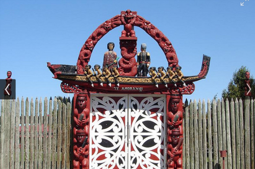
Nga Hau e Wha National Marae
Immediately exiting Cuthberts Green the trail passes Nga Hau e Wha National Marae, established in 1981. The carvings above the main gate depict the history of New Zealand, showing eight warriors paddling a canoe which is representative of all the ancestral canoes at Waitangi in 1840 and, opposite, Captain William Hobson, RN, Governor of New Zealand at that time. This entrance symbolises the Marae as a place for all citizens of New Zealand. Hence the significance of the name, which in English is ‘The Four Winds’.
The marae is administered by an Urban Maori Authority, which delivers education and social programmes among other services.
Nga Hau e Wha
Aranui
The name was adopted in 1911 and was confirmed in March 1912 when G. W. Russell M.P. received notice from the Telegraph Department that the new telephone bureau at Breeze’s Road was to be called Aranui.
Until housing, being a mix of private and state, commenced in substantial numbers in the early 1950s, much of the area comprised lupin and marram-covered sand hills. Nevertheless there were some existing roads that predated the 1950’s development, including Shortland Street and Rowses Road. Shortland Street first appeared in street directories in 1918, thereby predating the popular television series by 74 years.
Rowses Road
Rowses Road is named for William Henry Rowse, who in 1882 was the first foreman of the nearby Bromley sewage farm. In 1899 Rowse bought three acres on the corner of Rowses Road and Breezes Road. This was one of six titles subdivided from a 20-acre block by John Breeze in the 1890s. The area to the right of Rowses Road, after crossing Breezes Road, was not developed as housing until the 1970s. After being denuded, as part of the Sandhills Run, of its natural cover in the 19th century, the land throughout the area was infertile. Homeowners had to bring in topsoil to establish gardens. So, although there are fewer tall trees than many other Christchurch suburbs, the gardens that exist in Rowses Road belie the harsh environment that existed here in the 1920-40s.
Bexley Reserve
Rowses Road ends at a junction with Rowan Avenue. It was in the latter that the famous Aranui Speedway, which operated from 1949 to 1959 and spawned two world champions in Ronnie Moore and Ivan Mauger, was located. From the junction of Rowan Avenue with Rowses Road the trail follows a footpath through Bexley Reserve to Anzac Drive. Midway on the right is a pop-up container business offering land sailing activities (blokart, driftkart). To the left can be seen the outline and turrets of the North Avon Christchurch BMX Club. Because of earthquake damage, the track has been rebuilt and in early 2017 hosted the South Island BMX championships.

Shaggy ink caps in Bexley Reserve
Terry Conley Fields
Adjacent to the BMX club are the Terry Conley Playing Fields still in a state of disuse. The fields are named for Terry Conley who coached the Christchurch United Football Club in the early 1970s. It has been written that he “probably had more influence on Canterbury soccer than any other individual … in the 1970s he gave soccer the highest profile it has ever had in Christchurch and made United the country’s most successful team.”
Bexley
After crossing Anzac Drive the trail enters the Bexley red-zoned area, previously known as Pacific Park. The trail passes the entrance to Wetlands Grove, the name of which hints at the subdivision’s post-earthquake fate, having been built on reclaimed wetland. Many of the scattered trees and shrubs that remain poignantly indicate where section boundaries were. Although abandoned as a residential area, one occupied house defiantly remains.
Thanks to Stuart Payne for text and photos.
Flora & Fauna
Flora
Sept 2019 along this leg: 68 native Plant species including:-
Shore celery (Apium prostratum) near a moa hunters midden
Richards Toetoe (Austroderia richardii) spreading from plantings
Taupata (Coprosma repens) not indigenous to Christchurch but wild and abundant
Long hair plume grass (Dichelachne crinita) self-established native grass
Ngaio (Myoporum laetum) Freaky
Pahokoraka (Senecio quadridentatus) at New Brighton Bridge
Seagrass (Zostera muelleri) good news at McCormacks Bay
Kelp
Giant bladder kelp (Macrocystis pyrifera) a native seaweed
Fungi
Gilled mushrooms (Order Agaricales) a native mushroom
Protozoans
Metatrichia floriformis a native slime mold at Charlesworth
Fauna
Sept 2019 along this leg:-
11 species of native arachnids
2 species of native ray-finned fish
Grey duck/Parera and Mallard Anas superciliosa (grey) and Anas platyrhynchos (mallard) Grey ducks and mallards are found on many New Zealand lakes and rivers. Both male and female grey ducks are similar in appearance to mallard females. Because the two species interbreed, the plumage of male mallards varies considerably. Mallards are larger and more dominant, and as a result grey ducks are critically endangered.
New Zealand scaup Aythya novaeseelandiae:

NZ Scaup. Photo credit: Jeremy Taylor
This small diving duck can be found in waterways around Christchurch. The male has bright yellow eyes and both male and female have dark brown plumage.
Black swan Cygnus atratus: The black swan is an Australian swan that was introduced to New Zealand in the 1860s. It is thought that black swans have also flown from Australia and that most of the current population are descended from self-introduced birds rather than arising from the birds acclimatised in the 1860s. About 1000 black swans overwinter at the Te Huingi Manu Wildlife Refuge in the Bromley Oxidation Ponds.
Black-backed Gull/Karoro Larus dominicanus dominicanus: The black-backed gull is New Zealand’s largest gull. It has a white body with black upperparts, yellow legs and a yellow bill. Chicks peck at the red spot at the tip of the parent’s bill to stimulate regurgitation. Fledged offspring are mottled brown. Black-backed gulls scavenge from human populations and are more aggressive than the red-billed gulls they are often seen with. White-faced Heron, Egretta novaehollandiae.
Royal Spoonbills
Godwits
White heron/Kotuku (native) Ardea alba modesta:

Kotuku. Photo credit: Jeremy Taylor
The kotuku, or white heron, is treasured by Maori due to its rarity. It breeds at Okarito Lagoon on the West Coast, but is occasionally seen on the Avon-Heathcote estuary or in the Linwood Avenue canal. With a nationwide population of only 100-200, the kotuku is endangered in New Zealand, although the species is common elsewhere. The kotuku’s bright white plumage and black bill and legs distinguish it from other birds in the waterways. Kotuku feed in shallow waters on small vertebrates and invertebrates. The kotuku features on New Zealand’s $2 coin.
New Zealand shoveler Anas rhynchotis variegata: This duck is similar in size and shape to the grey duck and mallard, but has a longer bill with a rounder tip. Like the grey duck and mallard, shovelers are dabbling ducks, feeding from the surface rather than diving. The New Zealand population is about 30,000 and shovelers are occasionally seen on Christchurch waterways.
Paradise shelduck/Putakitaki Tadorna variegata:

Paradise Shelducks F+M. Photo credit: Jeremy Taylor
The Paradise shelduck is large and goose-like and can be found in parks and along waterways throughout Christchurch. Often found in pairs, the female is the more striking bird, with a white head and chestnut-coloured body. The male is darker, with a black head. In flight, the male gives a low honk, while the female answers with a higher-pitched call. Ducklings are brown and white-striped, and fledged young resemble the male.
Pukeko Porphyrio porphyria:

Pukeko. Photo credit: Jeremy Taylor
Pukeko are often seen alongside waterways and in paddocks. It has blue and black plumage, a red bill and shield and long red legs. Pukeko eat mostly vegetation, but will eat eggs, invertebrates and other small animals. Pukeko chicks are black and fluffy, with their parents’ large feet.